What can I do with CAD-Earth?
CAD-Earth® offers a very intuitive, easy to navigate interface.
Versions compatible with AutoCAD® and BricsCAD®.
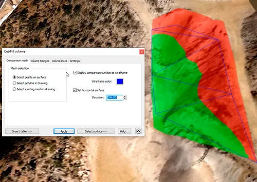
Instantly get cut-fill volume calculations
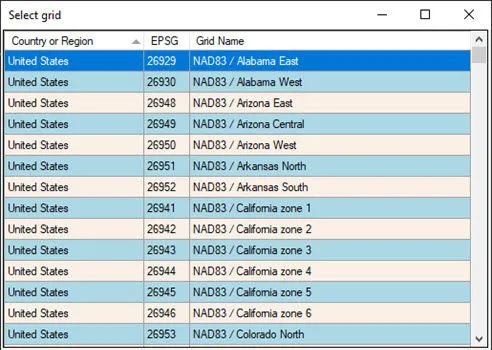
More than 3000 coordinate systems available
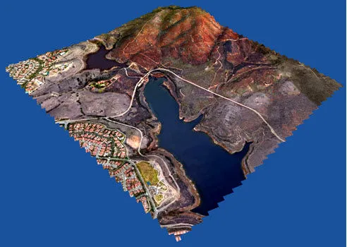
Import Google Earth™ terrain
Export AutoCAD objects to Google Earth™
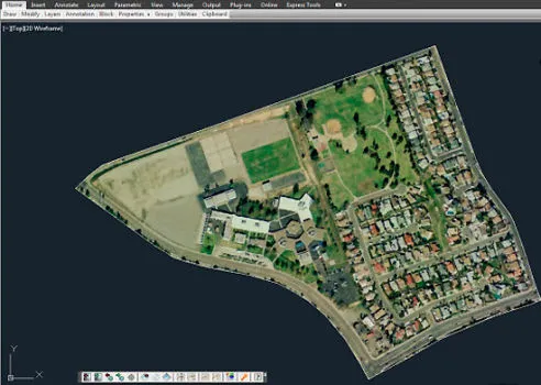
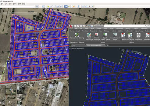
Import Google Earth image to CAD
Why choose CAD-Earth?
With over 10,000 worldwide users and counting, we offer…

Easy to use commands
You can pick CAD-Earth commands from a toolbar, from the screen menu or at the command prompt. Automatic command loading in each CAD session and extensive help in each step.

Accurate Image and object placement
You can define precise conversion parameters between your drawing and latitude/longitude coordinates by locating the site in a map, by selecting two points in the drawing or by choosing from more than 3000 coordinate systems worldwide.

Dynamic object updating
When you modify object settings, the corresponding contour lines, profiles or – sections are dynamically updated.

The most flexible pricing in the industry
We offer perpetual licenses and annual subscriptions, with free technical support and updates.

Works with Google Earth and Cesium and multiple CAD/Windows platforms.
It can be used with Google Earth free and Pro versions and in major CAD platforms (AutoCAD® and BricsCAD®). On Windows® 7, 8 & 10 64 bits.

Free Technical Support
Online Help, Tutorials and Videos Support via e-mail Support via remote control. New features requests.
Now it's easier than ever to insert
Your images, objects and terrain meshes.
What's new in CAD-Earth 8?
Use Al to improve image sharpness and color.
Images can be enlarged up to 4x times using an Al neural network to improve image resolution, light, and color balance.
Preview images before importing them
to ensure the image is positioned correctly, and select from different providers to choose the best image according to your needs.
New image providers.
You can now select from ESRI or Mapbox image providers when importing or inserting images.
New GPXZ terrain elevation and bathymetry provider.
High-resolution elevation data is provided from Lidar and bathymetry datasets where available. Information about the resolution and dataset used can be displayed.
CAD-Earth Features
Import and export 3D models
from DAE, 3DS, FBX, and OBJ files to AutoCAD, and export them and other 3D entities such as 3D solids, regions, meshes or polymeshes to Google Earth. 3D entities contained in regular or nested blocks can also be exported.
Terrain mesh editing commands
Import terrain meshes
What are the advantages of using CAD-Earth?
Get high-resolution Images
at no extra cost. Up to 256 curvature corrected image tiles with maximum close-up zoom can be obtained to cover large areas.
Automatic Google Earth startup and object location.
Commands can be easily executed,
See comparisons of the
advantages of CAD-Earth over the competition.
Start your free trial now!